
A research blog about the geocrimedata project; taking existing geospatial data making it useful for crime analysis. Funded as part of the JISC GeoSpatial Infrastructure programme.
Monday, 22 August 2011
Mapping riot locations using publicly available data
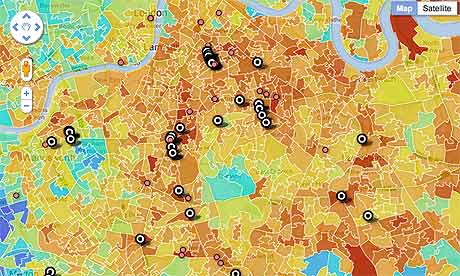
Following the riots in England, the Guardian newspaper have mapped the locations of some of the people charged with related offences and have compared them to deprivation data (the Index of Multiple Deprivation). This is an interesting and extremely relevant use of publicly available data.


Thursday, 4 August 2011
Project source code is available
We have just uploaded the Java source code for the GeoCrimeData project to a repository:
http://sourceforge.net/projects/geocrimedata/
At the moment the software is able to read in spatial data and calculate the mean path length for each road in a network. Mean path length is a measure of how easy it is to get from one road to every other road; roads with a low path length have been found to correlate with high vehicle and pedestrian traffic.
The image below shows the mean path length of roads using Open Street Map data for parts of Leeds, calculated using the software. It appears that 'major' roads (such as the motorway running through the centre of the map) have lower path lengths than the surrounding minor roads as we would expect (a low/green value indicates higher traffic volume). There are preliminary results and the software needs some tweaking, but hopefully a measure such as this should be a useful statistic for people who are interested in estimating how permeable/busy/accessible a street or neighbourhood is.

The next stages will be to improve the measure and run the software on UK data (rather than just a small area in Leeds).
http://sourceforge.net/projects/geocrimedata/
At the moment the software is able to read in spatial data and calculate the mean path length for each road in a network. Mean path length is a measure of how easy it is to get from one road to every other road; roads with a low path length have been found to correlate with high vehicle and pedestrian traffic.
The image below shows the mean path length of roads using Open Street Map data for parts of Leeds, calculated using the software. It appears that 'major' roads (such as the motorway running through the centre of the map) have lower path lengths than the surrounding minor roads as we would expect (a low/green value indicates higher traffic volume). There are preliminary results and the software needs some tweaking, but hopefully a measure such as this should be a useful statistic for people who are interested in estimating how permeable/busy/accessible a street or neighbourhood is.

The next stages will be to improve the measure and run the software on UK data (rather than just a small area in Leeds).
Tuesday, 5 July 2011
Results of a Survey of Crime Analysts
We have recently conducted a survey of ~30 eminent crime analysts from the UK and USA (as well as one person in Sweden!). The survey presented six maps which demonstrated some of the potential uses of geospatial data for crime analysts and asked the experts to give us their opinion on what they found useful/interesting about each of the new data sources.
 As an example, the figure left shows estimates of road traffic volume that were produced by looking at the structure of the local road network (using OS MasterMap data) and comparing this to occurrences of residential burglary. Analysts were asked whether they were familiar with this type of analysis, whether it would be useful for them to be able to easily access this type of data (or not) and how we might improve it.
The responses were extremely comprehensive and will be very useful in helping us to make sure that the products we produce will actually be useful to practitioners.
 As an example, the figure left shows estimates of road traffic volume that were produced by looking at the structure of the local road network (using OS MasterMap data) and comparing this to occurrences of residential burglary. Analysts were asked whether they were familiar with this type of analysis, whether it would be useful for them to be able to easily access this type of data (or not) and how we might improve it.
The responses were extremely comprehensive and will be very useful in helping us to make sure that the products we produce will actually be useful to practitioners.
Monday, 13 June 2011
Forthcoming conference presentations
We are going to a number of academic conferences in the coming months to present ongoing work on the project. The conferences that we'll be attending are:
- Environmental Criminology and Crime Analysis (ECCA) in South Africa
- European Society of Criminology (ESA) - 21st to 24th September 2011, Vilnius, Lithuania.
- European Colloquium on Quantitative and Theoretical Geography (ECQTG) - 2nd to 5th September, Harokopio University of Athens, Greece.
- Regional Science Association (RSAIBIS) - 6th to 8th September, Cardiff.
Monday, 16 May 2011
Crime and the social mosaic
The very existence of geospatial data enables us to ask much broader questions about the context in which crime occurs. For example, rather than just identifying some areas as having higher crime than others we are able to move the discussion forward to ask questions about what types of area have high crime. Are they socially disadvantaged? Do they have high concentrations of particular types of housing? Are they student areas?
But geospatial data sets also enables us to ask questions about what is next to a particular area and what effect that might have on crime within an area. For example, do poorer areas have higher crime if they are also surrounded by poorer areas? Do they have lower crime if they are next to affluent areas ? Do affluent areas surrounded by disadvantaged areas have higher crime than affluent areas bordering middle or high income areas?. Geospatial data gives us the opportunity for the first time to explore the extent to which an area’s crime rate is affected not just by the crime risks within the area (i.e .the housing, natural surveillance, offender population and community cohesion) but by the characteristics of its neighbouring areas. This truly is breaking new ground!
But geospatial data sets also enables us to ask questions about what is next to a particular area and what effect that might have on crime within an area. For example, do poorer areas have higher crime if they are also surrounded by poorer areas? Do they have lower crime if they are next to affluent areas ? Do affluent areas surrounded by disadvantaged areas have higher crime than affluent areas bordering middle or high income areas?. Geospatial data gives us the opportunity for the first time to explore the extent to which an area’s crime rate is affected not just by the crime risks within the area (i.e .the housing, natural surveillance, offender population and community cohesion) but by the characteristics of its neighbouring areas. This truly is breaking new ground!
Wednesday, 13 April 2011
Initial data analysis
At this stage of the project we are investigating the types of spatial data that are available and how they might help to provide contextual information to supplement crime data. For example, the figure below shows some burglary rates in two areas that are very close to each other. We have used the OS MasterMap Topography layer and spatially analysed each of the buildings to try to work out whether they are terraced, semi-detached, flats or detached.
 In general, more crimes are committed in the area labeled "B" than in "A". It also appears that the houses in area B are very similar to each other; most are terraced houses of similar design. Therefore it is possible that if someone is able to burgle one of the houses in area B, it is easier to burgle others as their design is so similar. The same is not true in area A which exhibits many different types of house design.
Of course there are a number of other explanations for the difference in the crime rates between the two neighbourhoods, but undoubtedly the physical environment will have an effect. Therefore this type of information might be extremely useful to crime analysts or other people who are interested in understanding the context behind crime rates. The GeoCrimeData project will continue to explore these types of data and perform analyses that might reveal interesting spatial information.

Of course there are a number of other explanations for the difference in the crime rates between the two neighbourhoods, but undoubtedly the physical environment will have an effect. Therefore this type of information might be extremely useful to crime analysts or other people who are interested in understanding the context behind crime rates. The GeoCrimeData project will continue to explore these types of data and perform analyses that might reveal interesting spatial information.
Wednesday, 30 March 2011
Radio Interview with Professor Hirschfield
Alex Hirschfield was recently involved in a discussion about the new police.uk crime mapping website. The discussion was broadcast live on the Andrew Edwards Drive Live Show on BBC Radio Leeds at 5.30pm on 1st February 2011 and is available here.
During the discussion it becomes clear that although crime data is an essential part of the crime analysis toolbox, we cannot understand crime just by looking at crime data - we need to understand the 'context' within which crime occurs. Is there something about land use or the population out there in the 'environment' that might explain why crime levels appear to be high or low?
This is at the heart of the GeoCrimeData project, we will analyse existing environmental data (such as road networks and land-use datasets) to add context to observed crime patterns.
During the discussion it becomes clear that although crime data is an essential part of the crime analysis toolbox, we cannot understand crime just by looking at crime data - we need to understand the 'context' within which crime occurs. Is there something about land use or the population out there in the 'environment' that might explain why crime levels appear to be high or low?
This is at the heart of the GeoCrimeData project, we will analyse existing environmental data (such as road networks and land-use datasets) to add context to observed crime patterns.
Tuesday, 1 March 2011
Budget
The following table illustrates how the budget has been allocated
| Item | Amount of budget allocated (%) |
|---|---|
| Staffing, estates etc. | 93 |
| Dissemination (conferences) and travel | 7 |
Projected Timeline, Workplan & Overall Project Methodology
Work Packages
The project will progress according to the work carried out in the following work packages. Mark Birkin is responsible for the overall project methodology.
WP1: User geospatial awareness, needs assessment and initial data exploration
The initial stage in the project is to engage with end users to explore their awareness of geospatial data, current levels and types of use and future analytical needs. This will be carried out using an online questionnaire that will be circulated to academic institutions and practitioners (police, community safety partners etc). Concurrently, initial data exploration will take place in order to identify potential data sets that can be used in the project. Andrew Newton and Nick Malleson are responsible for surveying users and collecting data respectively.
WP2: Data Access and the Creation of New High Resolution Data for EC and Crime Analysis
This stage will involve accessing relevant geospatial datasets and then analysing/modifying them to meet the needs identified in WP1. These tasks will require new methods to be developed in order to spatially analyse the input data sets and derive new data. Nick Malleson is largely responsible for WP2.
WP3: Case Study Pilot
WP3 will document a scientific case study using the data generated in WP2. The purpose of the case study will be to exhibit the new data sources to the community and demonstrate how they can be used to inform crime analysis. Andrew Newton is largely responsible for WP3.
WP4: Validation and Sustainability
The goal of WP4 is to evaluate the usability of the new datasets through interviewing stakeholders (identified in WP1). This is work will be carried out by Nick Malleson and Andrew Newton.
Work Package Timeline
The project will progress according to the work carried out in the following work packages. Mark Birkin is responsible for the overall project methodology.
WP1: User geospatial awareness, needs assessment and initial data exploration
The initial stage in the project is to engage with end users to explore their awareness of geospatial data, current levels and types of use and future analytical needs. This will be carried out using an online questionnaire that will be circulated to academic institutions and practitioners (police, community safety partners etc). Concurrently, initial data exploration will take place in order to identify potential data sets that can be used in the project. Andrew Newton and Nick Malleson are responsible for surveying users and collecting data respectively.
WP2: Data Access and the Creation of New High Resolution Data for EC and Crime Analysis
This stage will involve accessing relevant geospatial datasets and then analysing/modifying them to meet the needs identified in WP1. These tasks will require new methods to be developed in order to spatially analyse the input data sets and derive new data. Nick Malleson is largely responsible for WP2.
WP3: Case Study Pilot
WP3 will document a scientific case study using the data generated in WP2. The purpose of the case study will be to exhibit the new data sources to the community and demonstrate how they can be used to inform crime analysis. Andrew Newton is largely responsible for WP3.
WP4: Validation and Sustainability
The goal of WP4 is to evaluate the usability of the new datasets through interviewing stakeholders (identified in WP1). This is work will be carried out by Nick Malleson and Andrew Newton.
Work Package Timeline
 |
| Gantt chart depicting timescales of each work package |
Project Team Relationships and End User Engagement
Mark Birkin
Mark Birkin is Professor of Spatial Analysis and Policy in the School of Geography at the University of Leeds. He has wide-ranging leadership experience ranging from managing individual projects to institutional responsibilities. From 2001 until 2005 Mark was Director of the Institute for Interdisciplinary Informatics, and has also spent four years as leader of the Centre for Spatial Analysis and Policy. He is currently Director of External Relations in the School of Geography. Mark is the joint PI with Professor Mike Batty (UCL) of the GENeSIS node of ESRC‚’s National Centre for Digital Social Research, and is also director of the JISC project‚ Nationel e-Infrastructure for Social Simulation. He is editor of the journal Applied Spatial Analysis and Policy, a member of the editorial board of Transactions in GIS, and a member of the JISC Geospatial Working Group. Mark is responsible for the overall management of the project; overseeing that the project-wide workplan is maintained.
Nick Malleson
Dr Nick Malleson (BSc Computer Science, MSc Geo-Informatics, PhD Geography) is a research fellow in the School of Geography at the University of Leeds and a member of the Centre for Spatial Analysis and Policy (CSAP). Dr Malleson’s research is interdisciplinary and centres around the development and application of spatio-temporal computational models in the social sciences. His recently completed doctoral research implemented a complex micro-level model which used geospatial data and artificial intelligence to predict and explore occurrences of residential burglary in real cities. Nick’s role will centre around data capture, data analysis and the production of software tools.
Alex Hirschfield
Alex Hirschfield is Professor of criminology and Director of the University of Huddersfield's Applied Criminology Centre. He has over 30 years' experience in research and consultancy and has led large scale national evaluations for the Home Office (burglary reduction), Neighbourhood Renewal Unit (crime and regeneration) and Youth Justice Board (Preventing Violent Extremism). As a former geographer (BA and PhD from Leeds) who became a criminologist, Alex is in an ideal position to see the connections between both disciplines. Over the years he has developed a number of conceptual and analytical frameworks that identify both the end users of geospatial data sets for crime analysis and the potential uses of such data. He was one of the first to apply crime hotspot techniques to British police data in the early 1990s in an ESRC funded project and went on to develop a system for producing social, land use and demographic profiles for high crime areas. Alex is well-known in the Environmental Criminology academic community and as a member of the AGI’s Crime and Disorder Special Interest Group and a former Senior Home Office Adviser to Government Office Northwest, has strong connections with practitioners and end users. His role in the JISC Project will be to oversee the criminological aspects of the work, develop appropriate theoretical frameworks for the research and draw upon his external links to engage with the user community. To see how he gets on, just watch this space!
Andrew Newton
Dr Andrew Newton (BSc Geography, Msc GIS. PhD Environmental Criminology) has 11 years research experience in environmental criminology and expertise in working with geospatial data for research and policy evaluation projects using Geographical Information Systems. One of his key research interests is the geography of crime, and he secured funding in this area from a number of sources including the Home Office, Alcohol Education Research Council, Department for Transport Merseyside PTE, EPSRC, ERDF (EU), Government Office North West and the Alberta Gaming and Liquor Commission (AGCL, Canada). He has published widely in the field and has presented at over fifty national & twenty-five international conferences. His role will be to develop and analyse internet based survey to establish the current levels of awareness and interest exists in mapping crime and using geo-spatial data, to identify the user needs of this community, and liaise closely with these organisations and stakeholders in the development of this project .
Mark Birkin is Professor of Spatial Analysis and Policy in the School of Geography at the University of Leeds. He has wide-ranging leadership experience ranging from managing individual projects to institutional responsibilities. From 2001 until 2005 Mark was Director of the Institute for Interdisciplinary Informatics, and has also spent four years as leader of the Centre for Spatial Analysis and Policy. He is currently Director of External Relations in the School of Geography. Mark is the joint PI with Professor Mike Batty (UCL) of the GENeSIS node of ESRC‚’s National Centre for Digital Social Research, and is also director of the JISC project‚ Nationel e-Infrastructure for Social Simulation. He is editor of the journal Applied Spatial Analysis and Policy, a member of the editorial board of Transactions in GIS, and a member of the JISC Geospatial Working Group. Mark is responsible for the overall management of the project; overseeing that the project-wide workplan is maintained.
Nick Malleson
Dr Nick Malleson (BSc Computer Science, MSc Geo-Informatics, PhD Geography) is a research fellow in the School of Geography at the University of Leeds and a member of the Centre for Spatial Analysis and Policy (CSAP). Dr Malleson’s research is interdisciplinary and centres around the development and application of spatio-temporal computational models in the social sciences. His recently completed doctoral research implemented a complex micro-level model which used geospatial data and artificial intelligence to predict and explore occurrences of residential burglary in real cities. Nick’s role will centre around data capture, data analysis and the production of software tools.
Alex Hirschfield
Alex Hirschfield is Professor of criminology and Director of the University of Huddersfield's Applied Criminology Centre. He has over 30 years' experience in research and consultancy and has led large scale national evaluations for the Home Office (burglary reduction), Neighbourhood Renewal Unit (crime and regeneration) and Youth Justice Board (Preventing Violent Extremism). As a former geographer (BA and PhD from Leeds) who became a criminologist, Alex is in an ideal position to see the connections between both disciplines. Over the years he has developed a number of conceptual and analytical frameworks that identify both the end users of geospatial data sets for crime analysis and the potential uses of such data. He was one of the first to apply crime hotspot techniques to British police data in the early 1990s in an ESRC funded project and went on to develop a system for producing social, land use and demographic profiles for high crime areas. Alex is well-known in the Environmental Criminology academic community and as a member of the AGI’s Crime and Disorder Special Interest Group and a former Senior Home Office Adviser to Government Office Northwest, has strong connections with practitioners and end users. His role in the JISC Project will be to oversee the criminological aspects of the work, develop appropriate theoretical frameworks for the research and draw upon his external links to engage with the user community. To see how he gets on, just watch this space!
Andrew Newton
Dr Andrew Newton (BSc Geography, Msc GIS. PhD Environmental Criminology) has 11 years research experience in environmental criminology and expertise in working with geospatial data for research and policy evaluation projects using Geographical Information Systems. One of his key research interests is the geography of crime, and he secured funding in this area from a number of sources including the Home Office, Alcohol Education Research Council, Department for Transport Merseyside PTE, EPSRC, ERDF (EU), Government Office North West and the Alberta Gaming and Liquor Commission (AGCL, Canada). He has published widely in the field and has presented at over fifty national & twenty-five international conferences. His role will be to develop and analyse internet based survey to establish the current levels of awareness and interest exists in mapping crime and using geo-spatial data, to identify the user needs of this community, and liaise closely with these organisations and stakeholders in the development of this project .
Subscribe to:
Posts (Atom)